Table of Contents >> Show >> Hide
- Why Satellite View Turns On (and Why You Might Want It Off)
- The Quick Fix (30 Seconds): Switch Back to Default Map View
- Not Seeing “Default”? Here’s What You’re Looking For
- Map Type vs. Map Details (Don’t Accidentally Toggle the Wrong Thing)
- How to Keep Google Maps From “Sticking” to Satellite View
- When the Layers Button Is Missing or Won’t Open
- Bonus: If You Meant Apple Maps (Not Google Maps)
- FAQ: Quick Answers for Common “Why Is This Happening?” Moments
- Conclusion: Make Your Map Work for You
- Real-World Experiences: When Turning Off Satellite View Saves Your Sanity (and Your Battery)
Satellite view is awesomeuntil it isn’t. One minute you’re using Google Maps to find a coffee shop, and the next you’re staring at a highly detailed overhead photo of Earth like you’re auditioning for a spy movie. Roads get harder to read, labels feel busier, and your brain starts negotiating: “Is that a street… or a shadow… or a very aggressive tree?”
The good news: turning off satellite view on Google Maps for iPhone or iPad is quick, reversible, and does not require a secret handshake. Below is a step-by-step guide, plus troubleshooting and real-world tips so you can switch back to the clean, simple map view whenever satellite mode overstays its welcome.
Why Satellite View Turns On (and Why You Might Want It Off)
Satellite view shows aerial imagery instead of the standard “road map” look. That’s helpful when you’re trying to:
- Spot a building entrance (hello, confusing office complexes).
- Confirm landmarks (parking lots, parks, stadiums, that suspiciously large pond).
- Visualize terrain (especially if you also use Terrain view for elevation cues).
But for everyday navigation, satellite imagery can feel like trying to read directions written on a photograph. If you prefer clear roads, bold labels, and fewer visual distractions, switching back to Default map view is usually the move.
The Quick Fix (30 Seconds): Switch Back to Default Map View
If you only read one section, make it this one.
Step-by-step: Turn off Satellite View in Google Maps (iPhone/iPad)
- Open Google Maps on your iPhone or iPad.
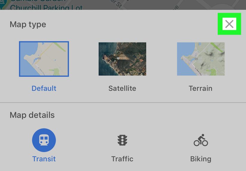
- Tap the Layers button (it looks like stacked squares) near the top-right of the screen.
- Under Map type, select Default (sometimes shown as “Map”).
- Tap anywhere on the map to close the panel (or hit the close button, depending on your version).
That’s it. Your map snaps back to the normal road viewlike the universe intended.
Not Seeing “Default”? Here’s What You’re Looking For
Google Maps on iOS typically offers a few base map types. The labels may vary slightly depending on app version, but the idea is the same:
- Default: the standard road map view (cleanest for navigation).
- Satellite: aerial imagery from above (the one we’re turning off).
- Terrain: a map style that highlights geographic features like hills and valleys.
If you’re seeing “Terrain” and “Satellite,” you should also see “Default.” If not, jump to the troubleshooting section.
Map Type vs. Map Details (Don’t Accidentally Toggle the Wrong Thing)
Here’s a common mix-up: Satellite is a map type. Things like Traffic, Transit, Biking, Street View, and other overlays are typically map details (layers you can stack on top of a map type).
Translation: switching off satellite doesn’t mean you lose helpful overlays. You can keep traffic on while using Default viewbecause you’re a responsible adult who enjoys knowing where the gridlock lives.
How to Keep Google Maps From “Sticking” to Satellite View
Google Maps usually remembers your last-used map type. So if it keeps reopening in satellite mode, it’s often because it was last left that way.
Best practice
- Before you close the app (or after you’re done satellite-snooping), switch back to Default.
- Then exit normally. The next time you open Google Maps, it’s more likely to start in Default view.
If your app still insists on satellite view like it’s paid extra for it, use the troubleshooting steps below.
When the Layers Button Is Missing or Won’t Open
Sometimes the real problem isn’t satellite viewit’s that you can’t access the control to change it. If the Layers icon is missing, unresponsive, or seems to do nothing, try these fixes in order:
1) Make sure you’re not in an “alternate mode”
In some situations (especially during active navigation or certain screens), on-screen controls can be minimized or hidden. Try tapping the map once to reveal controls, or back out to the main map screen.
2) Force-close Google Maps and reopen it
On iPhone/iPad, swipe up from the app switcher to close Google Maps completely. Then relaunch it. This clears minor UI glitches that can make buttons feel “dead.”
3) Update Google Maps
App interfaces change. If your Layers button moved, disappeared, or started misbehaving, updating can fix bugs and restore missing controls. Head to the App Store, search Google Maps, and tap Update if available.
4) Restart your device
Yes, it’s boring. Yes, it works more often than it should. A quick restart can reset stuck background processes that affect touch input or app rendering.
5) Reinstall Google Maps
If Layers still won’t open, reinstalling often resolves persistent issues:
- Delete Google Maps.
- Restart your iPhone/iPad (optional, but helpful).
- Reinstall Google Maps from the App Store.
- Open it and try the Layers button again.
Reinstalling is the “fresh start” option: it replaces corrupted app data and resets the interface.
Bonus: If You Meant Apple Maps (Not Google Maps)
It happens. People say “Google Maps” the way they say “Kleenex.” If you’re actually using Apple Maps, the steps are different:
- Open Maps (Apple’s app).
- Tap the Map Modes button (usually at the lower-right).
- Select a non-satellite option like Explore, Driving, or Transit.
- Close the panel.
If you’re definitely in Google Maps, stick with the Layers method above.
FAQ: Quick Answers for Common “Why Is This Happening?” Moments
Does satellite view use more data?
It often can, because satellite imagery relies on loading image tiles rather than simple vector map graphics. If you’re on cellular data and your map feels heavier or slower, switching to Default may improve performance.
Can I permanently disable satellite view?
Google Maps generally remembers the last map type you used. The closest thing to “permanent” is: switch to Default and leave it there.
Why do roads look weird or labels feel cluttered in satellite view?
Satellite imagery is a photo background. Labels and route lines must compete visually with real-world textures (trees, shadows, rooftops, parking-lot chaos). Default view is designed for readability first.
What’s the difference between Satellite and Terrain?
Satellite is imagery (photos). Terrain is a map style that highlights natural features like elevation changes and landscape contours. Terrain can be a nice compromise when you want geography without full-on aerial photos.
Conclusion: Make Your Map Work for You
Satellite view is a useful tooljust not always the right tool. If you want a cleaner screen, faster readability, and fewer “Is that a road or a river?” moments, switching back to Default view is the quickest win.
Remember the core move: Google Maps → Layers → Default. If Layers is missing or frozen, a quick update or reinstall usually gets you back in control.
Real-World Experiences: When Turning Off Satellite View Saves Your Sanity (and Your Battery)
People don’t usually set out to “be a satellite view person.” It kind of… happens. Maybe you’re trying to find the entrance to a restaurant tucked behind another building. You flip on satellite view to see the parking lot layout. Suddenly, you’re a rooftop detective: you can spot the drive-through lane, the back alley, and the one-way exit that always traps first-timers. Great! Mission accomplished. Then you forget to switch back.
Next day: you open Google Maps to get to a friend’s house. The map loads like a dramatic movie revealdark imagery, tiny road labels, and your route line trying its best to stand out against a neighborhood full of trees that all look like broccoli from space. If you’ve ever missed a turn because the route line blended into the background, you’re not alone. In Default view, roads are bold and predictable, which is exactly what you want when you’re driving and your brain is already busy tracking traffic lights, merging lanes, and that one cyclist who appears out of nowhere like a side quest.
There’s also the “I’m walking downtown and everything looks like a collage” problem. Satellite view can be incredible for getting your bearingsparks, plazas, building footprintsbut the moment you need to follow a specific street name, the vibe shifts. Default view is basically the friend who speaks clearly in a loud bar: not flashy, but dependable. For walking routes, it often reduces mental load. You’re not interpreting textures and shadows; you’re reading a straightforward map.
Another common experience: satellite view feels slower on cellular data, especially when you’re moving through areas with weaker coverage. The map may take longer to sharpen, labels may pop in late, and you might find yourself staring at blurry tiles like you’re watching your phone buffer reality. Switching to Default view can make the map snappier because it relies more on vector graphics, which are typically lighter to load.
And then there’s battery life. While battery drain depends on many factors (screen brightness is usually the biggest culprit), satellite imagery can add overheadmore visual detail, more data fetching, and sometimes more work to keep everything readable while you pan and zoom. When you’re traveling, the last thing you want is to trade 12% battery for a crystal-clear view of someone’s rooftop HVAC system.
The best “experience-based” habit is simple: use satellite view as a tool, not a lifestyle. Turn it on when you need contextentrances, landmarks, parking geometry, trailheadsthen switch back to Default for actual navigation. Think of it like using a flashlight: incredibly helpful in the dark, but you don’t leave it shining in your face while you’re trying to read a menu.