Table of Contents >> Show >> Hide
- Quick Map of What’s Ahead
- Border Bloopers & Map Mischief
- 1) The Four Corners is a real “four-state handshake” (and the marker is supposed to be right)
- 2) Minnesota has a little “chimney” that’s the northernmost part of the Lower 48
- 3) Kentucky has an “island-ish” chunk you can reach by driving through Tennessee
- 4) A library where you can read in the U.S. and whisper in Canada (without moving your chair)
- 5) The Mercator map makes Greenland look gigantic (and that’s not a small problem)
- Time Zones Doing Backflips
- Water That Refuses to Behave
- Height, Depth, and Other Vertical Drama
- Climate & Ecosystem Oddballs
- How to Experience These Odd Geographical Facts (Without Needing a Time Machine)
- Conclusion
Geography is supposed to help you feel oriented. And then you learn there’s a place where “tomorrow” is literally a short boat ride away,
a sea with no shores, and a U.S. state “chimney” that exists because old maps were… optimistic.
Below are 15 weird geography factsreal, verifiable, and guaranteed to make your brain tap the “recalculate route” button. Along the way,
you’ll see how borders get messy, time gets arbitrary, and water refuses to behave. (Honestly, water is the drama.)
Border Bloopers & Map Mischief
1) The Four Corners is a real “four-state handshake” (and the marker is supposed to be right)
There’s only one spot in the United States where four states meet at a single point: Arizona, Utah, Colorado, and New Mexico. It’s famous
enough to have its own monumentand yes, you can stand in four states at once and take the most aggressively triumphant photo of your life.
The twist: people sometimes claim it’s “in the wrong place,” but the legal boundary is tied to the original survey monument. In border terms,
the marker isn’t “off”it is the boundary.
- Odd takeaway: In geography, sometimes the object on the ground wins the argument with the math.
2) Minnesota has a little “chimney” that’s the northernmost part of the Lower 48
The Northwest Angle is the top-of-the-map oddity that looks like Minnesota is trying to poke Canadapolitely. It’s the northernmost part of
the contiguous U.S., and it exists largely because early border descriptions were based on imperfect geographic knowledge and imperfect maps.
Today, it’s still separated from the rest of Minnesota by water and borders, which means getting there can involve crossing Canada or
traveling across Lake of the Woods.
- Odd takeaway: One confusing sentence in a treaty can become a permanent road-trip challenge.
3) Kentucky has an “island-ish” chunk you can reach by driving through Tennessee
Kentucky Bend (also called the New Madrid Bend) is a tiny slice of Kentucky that’s cut off from the rest of the state by the Mississippi
River’s looping curve and surrounding borders. On a map, it looks like Kentucky misplaced a puzzle piece and Tennessee kindly held it for
safekeeping. In practice, if you want to visit by road, you typically enter through Tennessee. It’s a great reminder that rivers don’t care
about your nice, straight state line.
- Odd takeaway: Borders drawn near rivers come with a lifetime subscription to “surprise geography.”
4) A library where you can read in the U.S. and whisper in Canada (without moving your chair)
The Haskell Free Library & Opera House sits right on the U.S.-Canada border. Inside, the border is literally marked across the floor.
That means you can stand in Vermont and take a couple steps into Québecwhile still being inside the same building. It’s charming, it’s weird,
and it’s a perfect symbol of how borders are human ideas laid on top of shared places.
- Odd takeaway: Geography can be politically serious and delightfully absurd in the same hallway.
5) The Mercator map makes Greenland look gigantic (and that’s not a small problem)
A lot of people grow up with the Mercator projectiona flat map that keeps compass directions useful for navigation but wildly stretches areas
near the poles. The result is a classic mind-bender: Greenland can look roughly comparable in size to Africa on some wall maps, even though
Africa is far larger. It’s not “lying” so much as “choosing a trade-off,” which is cartographer-speak for “sorry, your eyeballs are going to
learn a lesson today.”
- Odd takeaway: Every flat map is a compromiseyour job is to know what it’s compromising.
Time Zones Doing Backflips
6) Two U.S.-Russia islands are only a few miles apart… but nearly a day apart in time
In the Bering Strait, Little Diomede (U.S.) and Big Diomede (Russia) sit close enough to feel like awkward neighbors. But the International
Date Line runs between them, creating a dramatic time difference. People love calling them “Yesterday Island” and “Tomorrow Island” because
the calendar flips between the two. It’s the kind of place that makes you wonder whether time is realor just paperwork with confidence.
- Odd takeaway: Geography can turn “see you tomorrow” into a very literal statement.
7) At the South Pole, time zones are basically a choose-your-own-adventure
Time zones are based on longitude, and at the South Pole all longitudes meet. So if you tried to do time zones “correctly,” you’d have every
time zone at oncewhich is a strong sign you should stop trying to be correct. In reality, research stations pick a practical clock. U.S.
stations like McMurdo and the South Pole often use New Zealand time to match logistics and flights. Geography sets the stage; humans pick the schedule.
- Odd takeaway: When you run out of longitude, you run your life on the time zone of your supply chain.
Water That Refuses to Behave
8) The Sargasso Sea is a sea with no shores
Most seas have coastlines you can point to on a map. The Sargasso Sea is different: it’s defined by ocean currents that form a circulating
boundary in the North Atlantic. No land borders. No “walk to the beach” moment. Just currents outlining a watery region that behaves like a
place even without a shoreline. If that sounds like a geography professor’s favorite trivia question, you’re correct.
- Odd takeaway: A “place” doesn’t always need landsometimes it just needs moving water with commitment.
9) Chicago made its river flow “the wrong way” on purpose
The Chicago River didn’t always flow the direction it does today. In a massive engineering effort, the city reversed its flow by building the
Chicago Sanitary and Ship Canal, sending water (and historically, wastewater) away from Lake Michigan instead of into it. It’s one of the most
famous examples of humans reshaping a watershed for public health and infrastructureturning a river into a city-scale plumbing reroute.
- Odd takeaway: “Natural flow” is sometimes just the draft version.
10) A natural “river shortcut” links the Orinoco and Amazon basins
The Casiquiare Canal is one of geography’s greatest flexes: a natural channel that connects two major river systems via the Orinoco (through
the Río Negro) and the Amazon basin network. It’s a reminder that drainage divides aren’t always clean “this side vs. that side” lines.
Sometimes, nature builds a connector that lets waterand speciescross what looks like a continent-scale boundary.
- Odd takeaway: Watersheds can have secret passageways. Geography loves a plot twist.
Height, Depth, and Other Vertical Drama
11) Earth’s “farthest from the center” point isn’t Everest
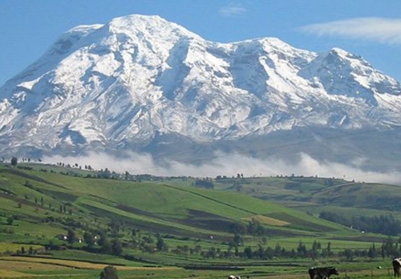
If you measure from sea level, Mount Everest is the tallest. But if you measure from Earth’s center, the winner changes because Earth is not a
perfect sphereit bulges at the equator. That bulge means mountains near the equator start farther from the center. As a result, Ecuador’s
Mount Chimborazo is often cited as the farthest point on Earth from the planet’s center. Same Earth, different measuring stick, different champion.
- Odd takeaway: “Highest” depends on whether you mean “tallest above sea level” or “farthest from the center.”
12) North America’s lowest point is a salt flat in Death Valley
Badwater Basin in Death Valley is the lowest elevation in North America, sitting well below sea level. The landscape looks like another planet:
bright salt crust, heat shimmer, and an almost rude amount of sunlight. Geologically, it’s part of a basin-and-range system where crust is
stretching, dropping valleys and lifting mountain ranges. It’s vertical drama in slow motionexcept your car’s thermometer will make it feel fast.
- Odd takeaway: “Below sea level” can still be bone-dry and blazing hot.
13) The deepest ocean point is in the Mariana Trench (and it’s truly, cartoonishly deep)
Challenger Deep, within the Mariana Trench, is widely recognized as the deepest point in the ocean. Depth estimates vary by method, but the
headline remains: it’s more than 10,000 meters deep (over 6 miles). That’s the kind of depth where pressure becomes the main character, sunlight
is a myth, and exploration requires specialized submersibles and sensors. It’s Earth reminding us that “down” has levels.
- Odd takeaway: The ocean floor isn’t one flat “bottom”it’s a landscape with valleys deeper than your imagination’s basement.
Climate & Ecosystem Oddballs
14) The world’s largest desert is Antarctica (yes, really)
“Desert” doesn’t mean “hot.” It means “dry,” based on very low precipitation. Antarctica qualifies because it receives so little moisture,
making it a polar desertand by area, it’s often described as the largest desert on Earth. It’s a place of ice that still counts as a desert,
which feels like a prank until you remember deserts are defined by water (or the lack of it), not by sand or cacti.
- Odd takeaway: If you define deserts by dryness, the coldest continent can win the desert contest.
15) The Great Lakes are basically an inland freshwater ocean
The Great Lakes system holds a staggering share of Earth’s surface fresh water. Depending on how you slice the statistics, it’s around one-fifth
of the world’s surface fresh waterstored in five connected lakes that shape climate, shipping, recreation, and ecosystems across a huge region.
On a map, they look like lakes. In real life, they behave like a freshwater sea: horizons, storms, and coastlines that feel ocean-sizedminus the salt.
- Odd takeaway: Some “lakes” are big enough to rewrite what you think a lake can be.
How to Experience These Odd Geographical Facts (Without Needing a Time Machine)
Reading weird geography facts is fun. Experiencing them is betterbecause your brain has a different reaction when a “map oddity” turns into a
real road sign, a real border line on a floor, or a real horizon of freshwater that looks suspiciously like an ocean.
Start small: make your next weekend outing a “micro-geography safari.” Pick one oddity within driving distancemaybe a local watershed divide,
a historic survey marker, a state-line monument, or a lookout where you can see how a river valley was carved. Bring a basic map app, but also
bring a curiosity app (your eyes). Notice how roads follow ridges, how towns cluster near water, and how “straight lines” on maps turn into
zigzags on the ground.
If you like border weirdness, plan a “line-hunting” day. Places like the Four Corners area or the Haskell Free Library show how borders can be
both serious and oddly casual. The key experience isn’t just crossing a lineit’s realizing how much history, surveying, and negotiation is
packed into a point that’s smaller than a parking space. Even if you never make it to those famous spots, you can still look for boundary
markers, old railroad survey points, or county-line monuments near you. They’re tiny reminders that maps are built, not born.
For time-zone weirdness, try a “time experiment.” Spend one day paying attention to local time as a human invention: sunrise, sunset, school and
work schedules, and how your body actually feels. Then read about the South Pole running on New Zealand time and the Diomede Islands living on
opposite sides of the date line. The experience is realizing that clocks are tools, not laws of nature. Geography shapes the light; people shape
the time.
Water oddities are the easiest to experience because water is everywhereand always up to something. Visit a riverwalk or canal and look for
signs of engineered flow: locks, levees, diversion gates, and “flood control” channels. Chicago’s river reversal is the blockbuster example,
but most cities have smaller versions: stormwater tunnels, reservoirs, and engineered waterways designed to keep drinking water clean and streets
dry. Once you learn to spot this, your hometown becomes a living diagram.
Want the “big landscape” feeling without flying across the world? Go Great Lakes. Even a short visit can deliver that moment where you realize
an inland body of water can produce weather, waves, and horizons that feel oceanic. Or, if you’re chasing ecosystem weirdness, look for places
where “expected climate” doesn’t match the vibe: foggy coastlines, rainforests with cool temperatures, deserts with snow at higher elevations,
and mountain passes that flip ecosystems in a matter of miles. The experience is learning that climate isn’t a single labelit’s a patchwork.
Finally, make it a game: create a “Weird Geography Bingo” card. Squares could include “stand on a county line,” “find a place shaped by a treaty,”
“watch a river bend and guess where it used to flow,” “spot a map projection distortion,” and “visit a place below (or far above) your usual
elevation.” Geography becomes unforgettable when it becomes personalbecause once you’ve stood in a place that contradicts your mental map, your
mental map upgrades itself.